


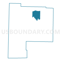
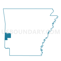
Ink Voting District, Polk County, Arkansas
About
Outline

Summary
| Unique Area Identifier | 527696 |
| Name | Ink Voting District |
| County | Polk County |
| State | Arkansas |
| Area (square miles) | 25.38 |
| Land Area (square miles) | 24.71 |
| Water Area (square miles) | 0.68 |
| % of Land Area | 97.33 |
| % of Water Area | 2.67 |
| Latitude of the Internal Point | 34.61464120 |
| Longtitude of the Internal Point | -94.13175410 |
Maps

Graphs
Select a template below for downloading or customizing gragh for Ink Voting District, Polk County, Arkansas


Neighbors
Neighoring Voting District (by Name) Neighboring Voting District on the Map
- Acorn Voting District, Polk County, AR
- Board Camp Voting District, Polk County, AR
- Cherry Hill Voting District, Polk County, AR
- Mena Voting District, Polk County, AR
Top 10 Neighboring County Subdivision (by Population) Neighboring County Subdivision on the Map
- Center township, Polk County, AR (7,255)
- Acorn township, Polk County, AR (1,503)
- Ouachita township, Polk County, AR (989)
- Fulton township, Polk County, AR (705)